Blackrock Creek Fishway
Old Bowen Road causeway in Pindi Pindi identified as a high impact barrier through a fish passage prioritisation project.

Blackrock Creek Fishway
In recent years, there has been significant investment by local councils and NRM groups in establishing infrastructure to improve the biodiversity within waterways, including the construction of fishways. Many of the fishway installations consist of rock ramp designs as this style is relatively inexpensive and easily retrofitted to a wide range of small to moderate sized barriers. Common locations suitable for retrofitting rock ramp fishways have been road causeways. Causeways generally form a small to moderate sized surface drop barrier and often incorporate a velocity barrier, created as water passes through culverts or across the road surface.
Within the Mackay Region, the Old Bowen Road causeway in Pindi Pindi was identified as a high impact barrier through a fish passage prioritisation project. The causeway was scored based on ecological, physical and socio-economic criteria, and was ranked 1st for the Blackrock Creek Catchment and equal 7th for the region.
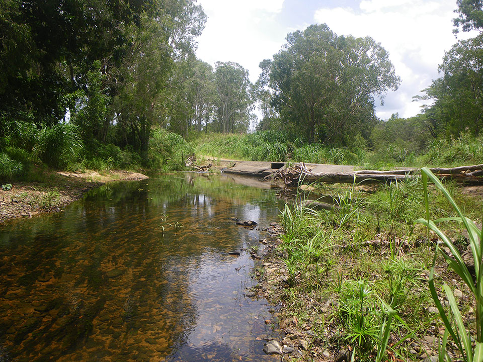
The causeway is of concrete and bitumen construction, consisting of a deck with approach and exit ramps as well as concrete scour protection aprons both upstream and downstream of the deck. The structure is approximately 42 m in length and 6 m wide. Incorporated into the causeway are three separate culvert barrels. Each barrel was set at different locations and elevations. Two of the barrels were functioning, while the third was entirely blocked with sediment and had become obsolete. The two functioning culverts included a 1200 x 500 mm RCBC and a 600 mm pipe culvert.
Fishway Construction
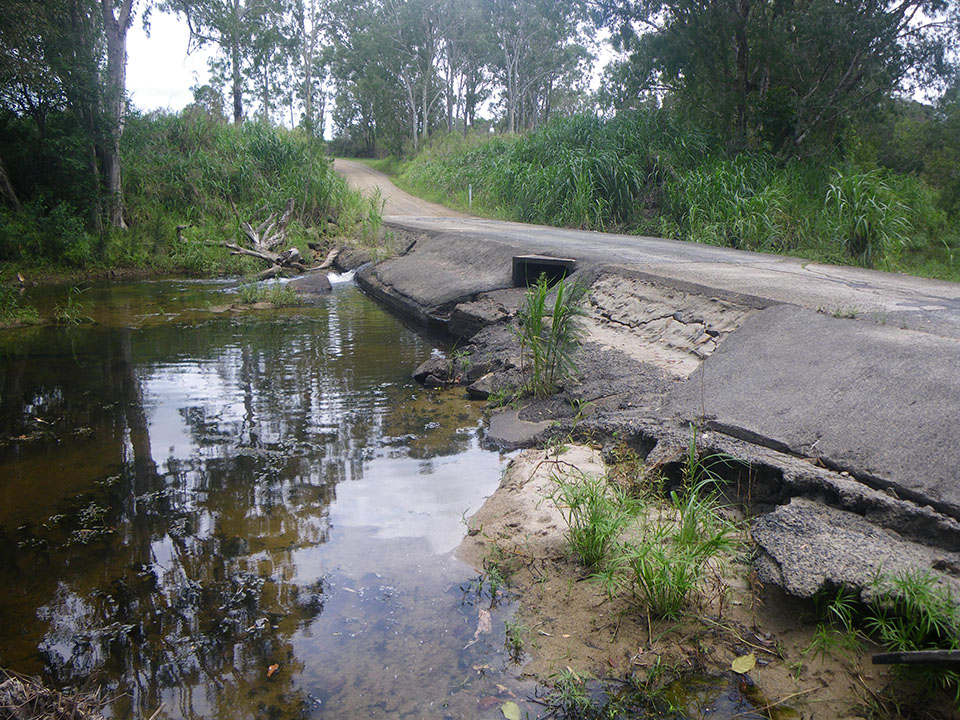
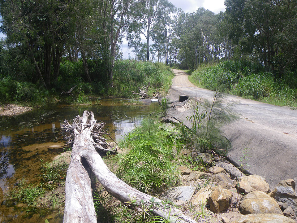
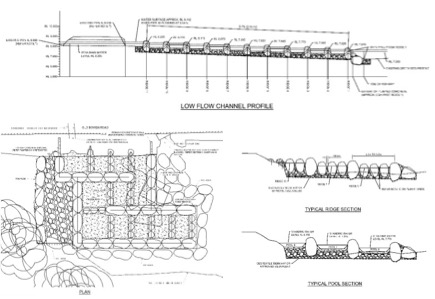
In 2016 Reef Catchments, in partnership with Mackay Regional Council, commissioned Catchment Solutions to design and construct of a rock ramp fishway for Old Bowen Road. The configuration of the fishway was a partial width design with 75 mm drops between ridges. Ridges were spaced at an average distance of 2.0 m and walls were spaced 3.0-3.5 m apart, creating pools with a depth of ~300 mm. The fishway also incorporated low and high flow slots to maximise operation during low flow conditions.


Rockramp Fishway the solution to the Old Bowen Road Causeway barrier.
In 2016 Reef Catchments, in partnership with Mackay Regional Council, commissioned Catchment Solutions to design and construct of a rock ramp fishway for Old Bowen Road. The configuration of the fishway was a partial width design with 75 mm drops between ridges. Ridges were spaced at an average distance of 2.0 m and walls were spaced 3.0-3.5 m apart, creating pools with a depth of ~300 mm. The fishway also incorporated low and high flow slots to maximise operation during low flow conditions.
Fishway Monitoring
Monitoring of the fishway was conducted in March 2017. A total of 409 individual fish at a catch rate of 4.19 fish/hr were recorded during the monitoring period. The catch consisted of 8 native species and 1 introduced species (guppy). Empire gudgeon were the most abundant fish, contributing more than 75% of the catch at a rate of 3.10 fish/hour. Flyspecked hardyhead and eastern rainbowfish were the next most abundant captures recording a CPUE of 0.57 and 0.32 fish/hour respectively. Catch rates of the remaining species ranged between 0.01 to 0.7 fish/hour.

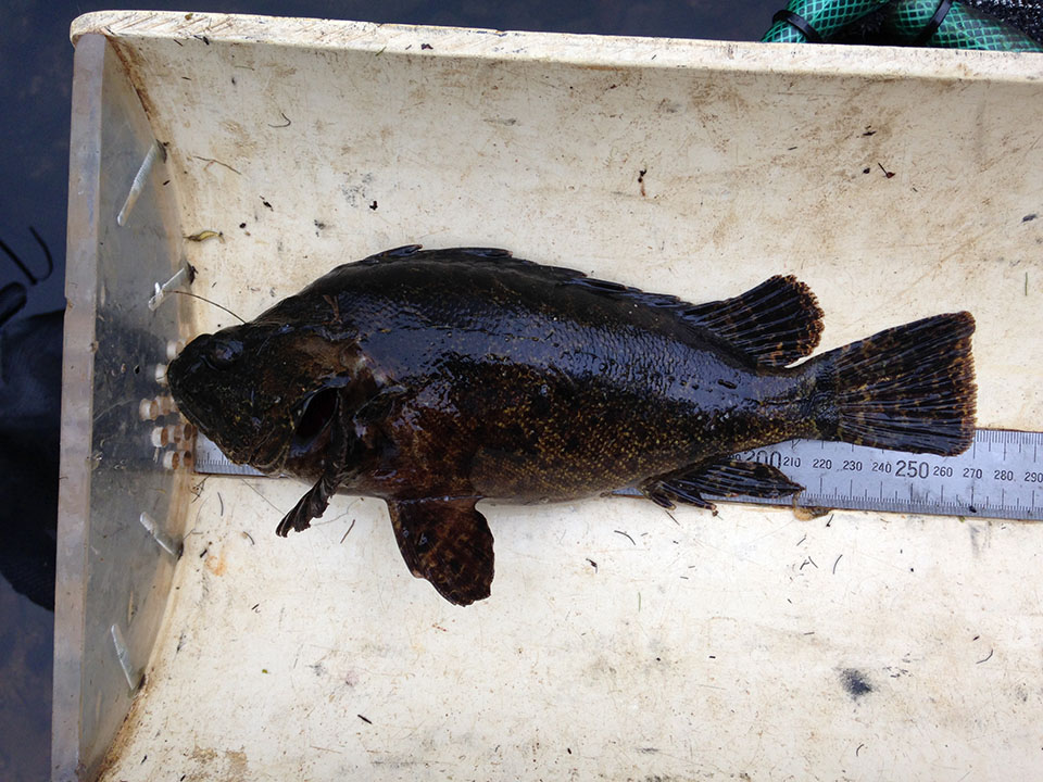
Blackrock Creek Fishway Monitoring bullrout (Notesthes robusta)
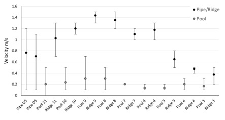
Average water velocities between the pools and ridges were relatively consistent throughout the fishway. However, within individual pools and ridges velocities varied considerably. Among the individual ridge measurement the minimum velocities ranged between 0.1 – 0.2 m/s and the maximums ranged between 0.8 – 1.9 m/s. Notably, maximum ridge velocities tapered off downstream of ridge 6, where the tailwater pool had drowned out the lower ridges. Minimum pool velocities ranged between 0.0 – 0.1 m/s, with maximums ranging between 0.3 – 0.7 m/s. Minimum and maximum velocities associated with the pipe culvert relate to measurements taken from the bottom and mid/surface water readings.
Findings
A total of 8 native and 1 introduced species were recorded during the monitoring period. This species diversity was similar to the diversity recorded during previous fishway monitoring programs conducted throughout the region. Catch rates recorded from Old Bowen Road fishway were slightly lower than recorded during previous trapping of another rock ramp fishway on the adjacent O’Connell River. In 2015 catch rates at Forbes Road fishway (Figure 1) on the O’Connell River were 7.7 fish/hour. Sampling at Forbes Road in 2017 did however, only recorded catch rates of 3.63 fish/hour. Given the similar catch rates at both locations, it’s likely that the reduced fish movement observed was the result of fewer fish moving at the time of sampling.
Stream flows are often cues for fish migration and greater levels of fish movement are generally associated with flow events. The conditions at Blackrock Creek, while elevated above base flow, were not associated with a defined flow pulse. It is likely that the fish moving at the time of sampling were not associated with migrations, rather opportunistic movement between local habitats within the reach of the fishway. This is supported by the species composition recorded, with the majority of the catch consisting of potamodromous fish.
Velocity measurements within the Old Bowen Road fishway varied within, and between pools and ridges. All of the species captured during the fishway monitoring have undergone swimming performance assessment in laboratory conditions. In the majority of cases the minimum velocities through the ridge slots were greater than the maximum swimming speeds recorded for the respective species. Excluding bullrout, empire gudgeon and pacific blue-eye, all of the species had recorded maximum swimming speeds 1.0 m/s. It is likely that fish are utilising the turbulent flow boundary layers to negotiate the higher velocities. This highlights the need for field based swimming trials to determine the swimming performance of native fish. Such information will provide greater accuracy when assigning design specifications for fishways, particularly for new barriers where no worsening to the level of fish movement is expected to result from the structure.
Old Bowen Road fishway was retrofitted to an existing culvert structure. The low light levels associated with the culvert barrel may still act as a psychological barrier for some species. It is possible that low light conditions may have contributed to the absence of some species during the current monitoring. While these conditions may be unavoidable when retrofitting fishways to existing culverts, consideration should be given to installing open grates over fishways that require the installation of new barrels.
More detailed information about the Blackrock Creek fishway can be found in the Blackrock Creek Fishway – Monitoring Report
If you would like information about any of Catchment Solutions projects please write to us or phone: (07) 4968 4216